Traces of violence in war crimes is a process that is non-linear, but they are inevitably kinetically projected on the built environment. The patterns of violence can be observed from different scales: spatial traces on the whole area of the conflict, urban deformations of neighborhoods / human communities, and architectural effects on buildings from their interaction with objects of violence (missiles, tear gas, barrel bombs). In this way, the process itself becomes the form.
The objective of this project is to visually narrate one of ways perpetrators choose architectural destruction as a means to exercise power across different sociopolitical contexts as well as how power as a process transforms into its own form.
Power is rather an abstract term — it takes on many different forms, from ideological to psychological, physical and political. I am exploring those manifestations on architectural buildings as the way to argue that buildings are becoming historical documents and function as devices of memory and change. They store information in its deformations and respond to external sensors, reflecting sociopolitical tensions. The effect of barrel bombs on the building is different from the effect of drone missiles. Each deformation in the building is a unique signature of its interaction with the object of violence, preserving the effect of the change and acting as memory. As the derivative of architectural destructions, spatial separation becomes a tool to control hierarchy and power.
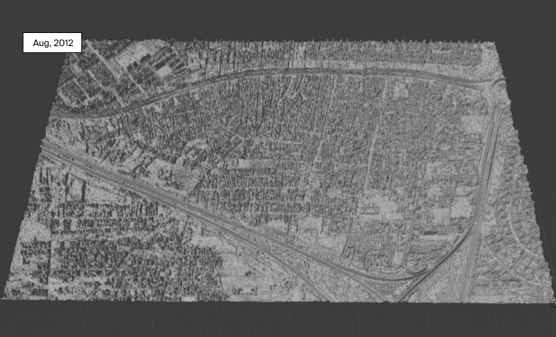
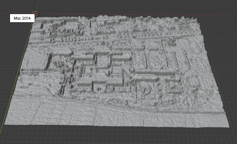
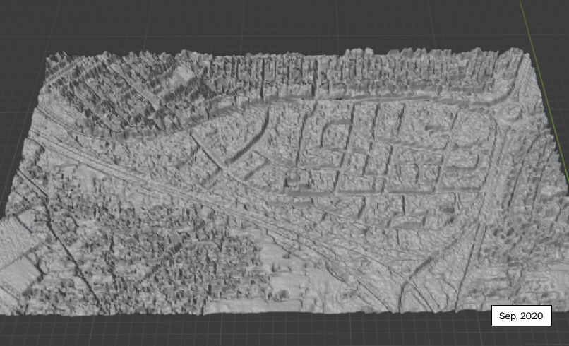
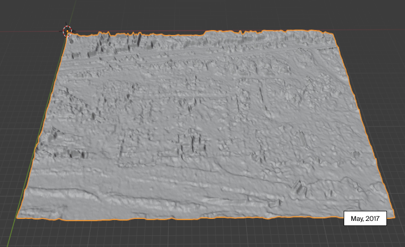
I start with satellite imagery because it visually offers similar viewpoints on architectural structures before and after acts of violence. The implied discord of temporal before-and-after imagery also suggests current politics of image resolution, access, and limitation of date and time choice. I then created some 3D models from satellite imagery to visually represent deformation in urban fabric when whole neighborhoods get destroyed. This project is still a work in progress as I am building up new visual approaches and collecting more data.
Ideological Power.
Architectural space becomes a critical technology of political control. We've seen this in times of totalitarian regimes, where architecture was one of the means to strengthen their international reputation. They seem to be in competition with each other and with the whole world, trying to construct buildings-champions: the highest skyscraper, the most spacious stadium, or at least the most beautiful pavilion in the international exhibition.(Source) Conversely, in crimes against humanity and war crimes it is the destruction and deconstructive narrative of urban spaces that establishes power over human communities and the environment.
Situating architectural scale in context of military conflict, the analogous pattern of power is the scale of destructions and the importance of overtaken building types. The ideological power is expressed by occupying buildings that function for educational, media, and religious purposes as you can see in this set of images. Attacking these buildings, perpetrators establish a long-term strategy for a political control in the area, disseminating propaganda campaigns, initiating training programs, etc.(Source)
These mosques and universities are large as they were constructed to accomodate the public. Ideological power suggests not only spatial erasure in maps, but also erasure in human memory of the places that in turn redefines their personal relationship with those spaces. We see here how spatial manipulation is manifested through architectural size. Later on, we will see how it is also manifested through distance and scale.
Psychological & Physical Power.
Urban Deformation.
Alfred North Whitehead, a mathematician and philosopher, once said that reality is made of processes rather than independent material objects constructed by bits of matter, and that processes are defined by their relations with other processes.
While destruction of the built environment is the medium for socio-political processes, the erasure of urban fabric thus becomes the outcome of such processes. Spatial manipulation operates at a much larger scale, where narratives of erasure in urban spaces enable attempts in ethnic cleansing, segregation, and violent crimes. Two chosen examples are the Syrian neighborhood that was completely destroyed within a span of a year and the destruction of one of the largest religious buildings in Syria. I then made 3D models from before-and-after satellite imagery to see the urban transformation (reconstruction) of the neighborhood and the volumetric differences of the destruction for the mosque.
Methodology & Remarks.
While architecture offers the lens to critique sociopolitical climate, deconstruction in visual counterforensics becomes a tool to restore memory from geometric shapes and human mind. I am reminded by this quote, "Deconstruction must through a double gesture, a double science, put into practice a reversal of classical opposition and a general displacement of the system. It is on that condition alone that deconstruction will provide the means of intervening in the field of oppositions it criticizes and which is also a field of non-discursive forces."(Marges)
The history of geometry is founded on the assumption of memorylessness. But what open-source visual investigative practice teaches is that it can store effects of past actions and thus has the notion of memory. A shape of objects such as buildings is the medium of reconstructing history through a study of deformations and inferences, unfolding forensic information. Eyal Weizman once said, "Histories of violence will always have their lacunas and discontinuities." I think it is most visible when using satellite imagery. Not only is it because of gradual disappearance of human scale and more accurate details with higher zoom levels, but also because of the politics of pixel resolution, access to high quality imagery, and corporate ownership of satellites. This affects time choices as well as places as it is seen in the project.
Counter-cartographic practice grows from the a long tradition of post-colonial practices of mapping back. Like maps, satellite imagery today is a tool that can be used to reconstruct reality, detect invisible violence, and hold power accountable. In visual investigations, it is architectural satellite imagery that becomes a "form of cartography" to spot urban violence performed in war crimes. (Eyal Weizman)
Author: Karina Nguyen. Tools used for the project: HTML/CSS, Javascript, Blender, Python STL library, Google Earth. Many thanks to Eyal Weizman for inspiring this project through written book, Christiaan Triebert for valuable conversations on various topics, Zachary Lamb for teaching urban design concepts, Lindsay Freeman for letting me work on a legal investigations case and learn about international law, John Isom for introducing the concept counter-cartography, Stephanie Croft for letting me collaborate with SITU Research, A.J. for introducing me satellite imagery analysis, and Linus Lee for constant feedback and coding help. This project would have never been possible without my experience at Human Rights Center and UC Berkeley.